
Geospatial Asset Management with SAP and GIS
Optimize Your Business
Location and environmental attributes are crucial information for maintenance planning and execution on geographically distributed assets like pipelines, rail tracks, and high voltage cables.
Are you struggling with connecting location attributes to asset data?

Business Pressures
- Difficult to effectively plan, schedule and sequence maintenance routes without spatial data
- Mobile workforce lacks critical asset and spatial data to efficiently perform field work
- Regulatory reporting is complex and time consuming due to disparate data
- Increasing risk of having incomplete asset record information

System Challenges
- Unsynchronized asset registries separately maintained in GIS and SAP
- Dual maintenance of asset data performed in disconnected systems
- Difficulty identifying a trusted source of truth (system of record) for data
- Custom SAP-GIS interfaces are expensive, complex and difficult to maintain
Geospatial Asset Management Starts With a Business model
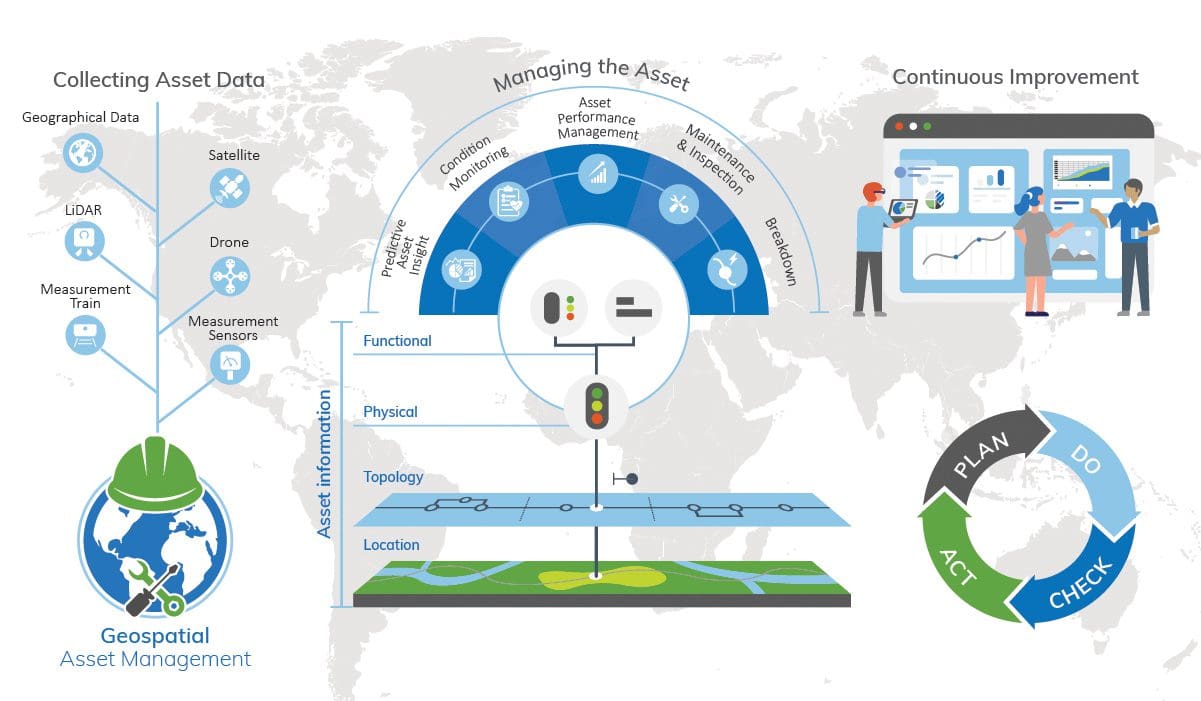
Embed geospatial and asset data in your asset management model to ensure asset uptime for service delivery and/or production purposes. By combining geographical, sensor, and asset data, the performance of an asset can be managed to prevent unplanned downtime. The graphic below shows how asset data types connect to ensure the performance of your assets.
GIS and SAP Are Complementary
GIS
Strengths
- Spatial analysis
- Route optimization
- Location awareness
- Environmental awareness
SAP
Strengths
- Resource management
- Work management
- Asset traceability
- Cost tracking
Answers These Questions
- Where are my assets?
- How are they connected?
- What is the most effective route to reach them?
- Where should new assets be installed?
- What major landscape features and attributes are they near?
Answers These Questions
- What is the state of my assets?
- How do I maintain my assets?
- How do I fix my assets?
- What is the work history for this asset and assets like it?
- How do I manage costs associated with asset construction and asset maintenance?
- What are my preventive maintenance strategies?
Integrate GIS and SAP with Rizing Mercury
Rizing’s Mercury simplifies and accelerates SAP and GIS integration by synchronizing data between SAP plant maintenance and GIS like Esri and GE Smallworld.
Browser-based Field and Office Data Collection with Rizing OmniSpatial
 Rizing’s OmniSpatial is a progressive web application for field and office data collection and maintenance workflows. The application works seamlessly with popular geospatial web services, including Esri map and feature services. OmniSpatial provides asset location for traditional map points, lines, and polygon modeled assets. It also allows data to be collected on linearly referenced features using Esri’s traditional linear referencing and Rrads and highways web services.
Omnispatial Benefits
Map (coordinate) and roadway (linear) data collection methods
Device agnostic solution runs on any web browser
Integrates data from multiple web services and file formats
“Broom sweep” collects multiple linear and point features in one pass
Data preparation tools guide users through downloading data for offline use
Record photos, audio, notes, and video along with attribute data