
Chapters in this Series:
1 | 2 | 3 | 4 | 5 | 6 | 7 | 8 | 9 | 10
This is the sixth in a series of 10 articles addressing the benefits of integrating a Geographic Information Systems (GIS) system with SAP®.
Parking lots in Northern Minnesota often provide electrical outlets for car owners.
And they aren’t just for hybrid owners.
When it’s Minnesota-cold, batteries don’t hold a charge as long. Engine oil gets thicker, making it harder to turn over the engine while starting. Owners use those outlets to plug in battery chargers and engine block heaters to make sure they can get home.
Environmental Factors that can influence assets
Cold weather is just one way the environment can affect a physical asset like a car. Other climate and environmental factors include:
- Extreme heat / arid conditions
- Freezing and thawing cycles
- High winds / tornadoes / hurricanes
- Earthquakes
- Mountains / high elevations
- High vegetation
- Snowstorms
- Landslides
- Fresh or saltwater shorelines
- Being underwater
Lack of GIS Data Doesn’t Help
Without spatial analysis, maintaining asset health becomes a guessing game. Ignoring climate and environmental factors will cause asset health to decrease and/or asset risk to increase at unacceptable rates.
By integrating SAP and GIS, environmental data visually overlays asset location, highlighting potential issues.
SAP + GIS = Better Decision Making
Is it summertime? Powerlines can expand and droop with heat. Pull up a map of your service territory, overlay that view with one showing temperature readings, and now you know where to go inspect.
Are your assets in a forest? Vegetation grows faster when it’s warm. A similar view of your service territory would show areas that need more frequent inspections.
GIS Data Layers
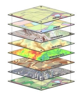 Many types of data can be integrated into GIS and represented as a map layer:
- Streets
- Parcels
- Zoning
- Flood zone
- Client locations
- Competition
- Shopping centers
- Office parks
- Demographics
Layer Up
Stack these layers visually and undetected spatial trends and relationships will appear, revealing insight about relevant characteristics of a location.
Underground assets like metal pipelines can be prone to corrosion. Soil conditions impact corrosion rates, so an SAP/GIS integration would allow asset managers to add a data layer showing local soil conditions. The combined data will help them decide where to treat pipes with a protective coating or install them with cathodic protection to protect against corrosion.
System of Record
Having SAP as your system of record for asset maintenance means using it for routine inspections, preventive maintenance, and corrective maintenance.
When assets need to be maintained or replaced, SAP captures detailed information in a Maintenance Notification. The information captured is most valuable for analysis when it’s recorded with simple codes vs. plain text.
SAP Codes
Standard SAP code categories include Cause and Damage. As assets are repaired and replaced over time, cause and damage factors should be recorded. SAP Maintenance Orders can then automatically capture material and labor costs.
Armed with spatial analytics tools, causes, damage, frequency, and costs etc. can be compared with the climate and environmental factors listed above.
Real Data for the Real World
In an ideal world, assets would always be in environmentally favorable locations. Here in the real world, locations are often influenced by customer location, the availability of suitable access, power, or other resources.
By combining the detailed asset history SAP provides and the spatial awareness and other data layers that GIS allows, maintenance engineers are now capable of designing an inspection and prevention plan that will maximize investments and prolong asset health.
Chapters in this Series:
1 | 2 | 3 | 4 | 5 | 6 | 7 | 8 | 9 | 10