
Chapters in this Series:
1 | 2 | 3 | 4 | 5 | 6 | 7 | 8 | 9 | 10
This is the final installment in a series of 10 articles addressing the benefits of integrating a Geographic Information Systems (GIS) system with SAP®.
Regulatory compliance can take many forms. Asset-heavy organizations like pipelines, electric utilities, or rail networks often share regulatory-related challenges.
Let’s look at some of the cross-industry regulatory activities and how an integrated SAP/GIS platform will save and money while ensuring companies remain compliant.
Identification of Regulated Work
If you have assets that move, they probably go through areas that have specific regulatory requirements – like environmentally sensitive sites, a place with a Right of Way, or indigenous-owned land. If so, you have a process for getting the necessary permits to do the work you need to do.
But how efficient is that permitting process?
SAP GEO Framework
By integrating GIS into SAP using SAP’s Geo Framework (GEF), work can be layered on top of regulated areas (represented as polygon features) on a shared map.
The system can be programmed to auto-load the necessary permitting operations into the work orders falling within the regulated areas.
This will save time, ensure the permitting process isn’t forgotten, and eliminate crews getting turned away or fined for not having the correct permits.
Auto-generated Maintenance Plans
The assets located inside regulated areas may also require different inspection and maintenance schedules. The integrated GIS/SAP system can automatically generate or update plans and schedules for them.
For example, the natural gas pipelines travel through populated areas require more inspections and maintenance. As that population grows, pipeline companies need to reassess their maintenance and inspection plans accordingly.
By using a GIS-enabled system, planners can bring in a population analysis component, allowing SAP to automate the analysis and adjustment of those plans.
Regulatory Reporting Challenges
Reporting requirements imposed by regulatory bodies is a fact of life for many companies. Reports often look different, but the challenges are the same:
- Gathering data across multiple systems is inefficient
- Data collected from different systems about a common asset rarely lines up
- Data in either system may be old and inaccurate
Automated Interface is Good
Back in chapter two of this series, we talked about the benefits of automating the synchronization of SAP and GIS.
Having that automation in place – and the resulting synchronized data between the two systems – is essential when regulatory reporting requirements are present.
For example, both GIS and SAP may store the length of a pipeline running through a certain tax jurisdiction. GIS may get a length number from analyzing shapes on a map, while SAP’s length would include additional pipe lengths required by an elevation change.
Mismatched Data is Bad
The numbers won’t match. And if they both make it into a common report, regulators may assume neither length is correct and respond with an audit or a fine.
An automated interface between GIS and SAP would show the correct geometry from GIS and the correct length values from SAP. The data doesn’t have to be manually combined, either system will have the correct data, and the final report will satisfy the regulators.
Proof of Regulatory Compliance
Regulators often ask for proof of the data that reports show. One example is inspections of infrastructure. The requirements are driven by public safety. The records are the first place investigators will look after something goes wrong. Having a proper process in place is essential.
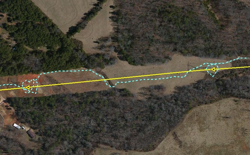
GEF shines for this. It allows work to be rendered as geometry and be pushed to SAP Work Manager, which gives users the exact location of the required inspection.
During the inspection, Work Manager captures the device coordinates, which creates evidence for investigators. That data gets attached to the work order for recall later.
This data can also be used to make sure the inspection routes are optimized, and also be published to the GIS system to show inspection times for the asset on the map.
Easier Compliance
Needless to say (but we will anyway), regulatory compliance is critical.
Identifying, reporting, and substantiating work subject to regulation is a challenge for all of us.
But we believe an integrated GIS/SAP system provides solid benefits for keeping asset-rich companies with compliant.
Chapters in this Series:
1 | 2 | 3 | 4 | 5 | 6 | 7 | 8 | 9 | 10