
Chapters in this Series:
1 | 2 | 3 | 4 | 5 | 6 | 7 | 8 | 9 | 10
This is the first in a series of 10 articles addressing the benefits of integrating a Geographic Information Systems (GIS) system with SAP®.
The Advantages of Integrating GIS and SAP
In industries with dispersed or “field” assets, critical information about these assets are maintained independently in a GIS system as well as in an ERP system (SAP) which has the capability and functionality for Enterprise Asset Management (EAM).
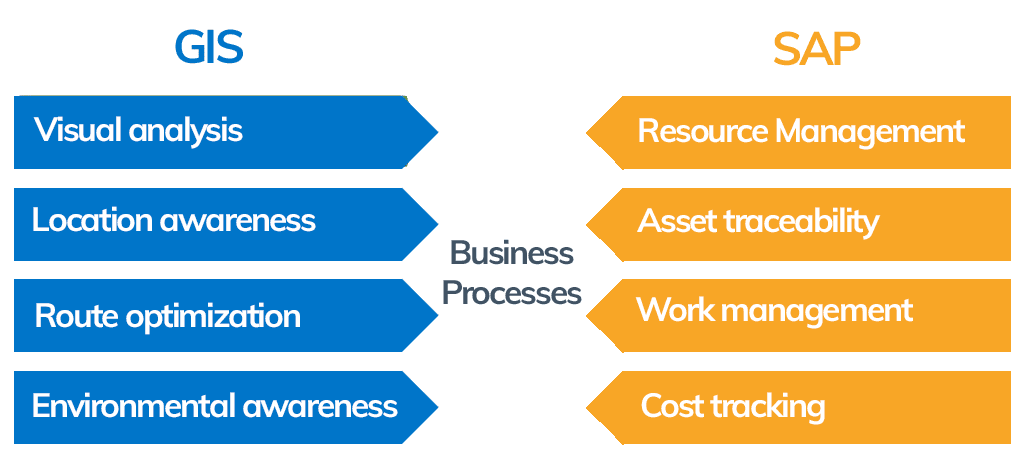
The overall functionality of a GIS-SAP eco-system can’t done comprehensively in either one. They both have their strengths. Together, they can complement each other.
A little about what each does best:
A GIS system answers questions like:
- How are these assets connected?
- How do I reach them efficiently?
- What significant landscape features are they near?
- How can I spatially group them?
- How can I make maintenance/inspection routes more efficient?
An EAM system like SAP answers questions like:
- What is the state of my assets?
- How do I maintain them?
- How often do I inspect and perform preventive maintenance?
- How do I manage costs associated with asset construction and asset maintenance?
- What qualifications are needed by the workforce who maintain my assets?
- What materials (spare parts) and tooling are necessary to have in inventory?
- How do I insure regulatory compliance?
- How do I minimize downtown or disruption in the services we provide?
The irony is that both systems often refer to the same physical assets.
GIS and SAP have different strengths:
Challenges of not linking GIS and SAP:
- High manual effort to ensure legal compliance.
- Inability to identify the “System of Record” for given asset data.
- Inability to perform spatial analysis of field work (including inspection, preventive, and corrective work).
- Challenges in planning and scheduling work with ability to view spatially.
- Inability to provide asset data as well as spatial data to a mobile workforce.
- Inability to optimize maintenance routes due to lack of spatial data.
- Challenges in linking asset health to environmental factors.
- An increased risk of having incomplete information on a given asset.
- Inability to utilize GIS and SAP for material traceability.
Benefits of linking GIS and SAP:
- Entry of asset data “once” and share it between systems as necessary – eliminating dual maintenance.
- Synchronized data between GIS and SAP.
- Spatial data and technical data of an asset form one logical entity providing a 360° view on the technical asset.
- With Geo-enablement in SAP (GEF)- the ability view and analyze assets and work spatially in SAP.
- Increased ability to deliver asset spatial information and attribute information to mobile workforce.
- The ability to further analyze SAP work packages in a functioning GIS system.
- Support for material traceability.
- Controlled redundancy: achieve good performance in both systems.
1+1= >2
Without efficient GIS – SAP integration, the capability to analyze and optimize complete asset health can be compromised. Companies who don’t have comprehensive asset information and maintenance history are at greater financial and public safety risk.
These challenges highlight the need to integrate GIS and SAP. Successful integration of these two powerful applications exceeds the sum of their parts.
Begin your GIS and sap integration
Our real-world experience of working with many customers in various industries gives us a wealth of knowledge to offer. We can leverage our proven framework and methodologies to help deliver consistent results and benefits. Contact us to learn more.
Chapters in this Series:
1 | 2 | 3 | 4 | 5 | 6 | 7 | 8 | 9 | 10