
Chapters in this Series:
1 | 2 | 3 | 4 | 5 | 6 | 7 | 8 | 9 | 10
This is the ninth in a series of 10 articles addressing the benefits of integrating a Geographic Information Systems (GIS) system with SAP®.
The Benefits of Route Optimization
If your corporate assets are all over the map, you’re probably spending a lot of money just getting to them.
Advanced travel route planning and optimization can help lower those costs.
Companies can leverage their Enterprise Resource Planning (ERP) and Geographic Information System (GIS) to optimize routes and save money in fuel consumption, employee time, and other areas.
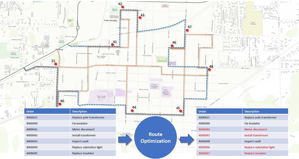
Route Optimization without GIS
Without the spatial data that a GIS provides, factors like job duration, asset criticality, or regulatory priority can still be accounted for in route planning.
But, lacking either distance or location, it’s more of a sequence than a route.
You can turn a sequence into a truly optimized route by adding work location information to your data.
Keeping the Human Element in Route Optimization
Without GIS-enabled route planning, field workers often figure things out on the fly. They get used to managing for themselves.
Maintaining that autonomy while improving job dispatching and execution can be a challenge.
Make sure to continue to include your field technicians in route planning. They can give you valuable input on traffic patterns, new construction bottlenecks, or customer requests that your databases won’t have.
Address Locations and Precise Geometry
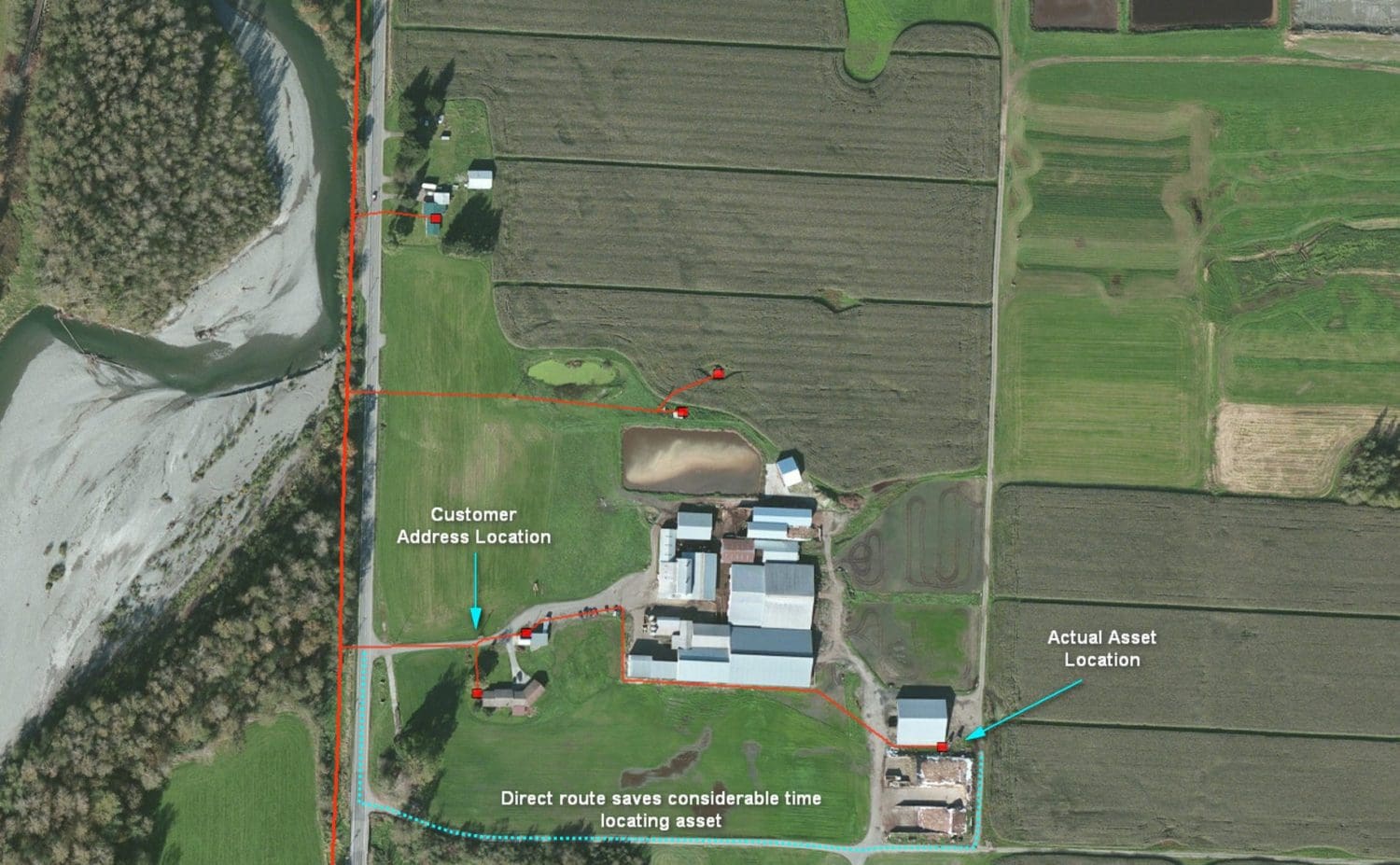
Traditionally, job sites were specified using addresses. But using only addresses for routing is problematic. Utility crews trying to replace a water meter and armed with only an address can still end up killing time trying to find the actual work site, determine a good way into it, and then locating the meter on the property.
It gets harder yet.
Rural locations or new construction sites may not have an address. Assets aren’t always linked to an address.
Even with GIS mapping software and smart, connected apps, this is the nature of addressing.
And, as tough as it is to say, it may never improve.
use Lat/Long for more optimized routes
When assets are managed in an integrated ERP/GIS system, planners can use precise latitude/longitude coordinates rather than addresses.
Mapping applications can now generate driving directions to an asset’s actual location. This is especially valuable when dealing with underground or hidden equipment.
optimized routes for first responders
First responders also benefit from precise locations. They would much rather be routed to the lat/long coordinates of the gas valve they need to turn off than the address the valve is near to.
Some cities also have non-unique or confusingly similar addresses. In an emergency, the difference between 400 First Avenue and 400 First Street could literally be life or death.
Remote Asset Locations
Your GPS won’t be of much help for corporate assets located in areas too remote for roads. Utility companies may use all-terrain vehicles or helicopters to visit some job sites. In these situations, planners benefit from more advanced technology.
For example, a west-coast-based utility uses a mobile app that combines asset information from an ERP system with driving directions and satellite views from a GIS system.
The combination proved useful on a recent job. While traveling to a location in the mountains, they used normal driving directions most of the way. Closer to the location, they switched to satellite view which revealed an unmapped dirt road that provided a shortcut to their destination.
Using Shapes for More optimized routes
Jobs aren’t always at a single location. For example, a gas leak survey would follow a street route. It would have a defined start and end point. If those points are known to an ERP/GIS integration, the work can efficiently be sequenced with other point-to-point jobs.
GIS-enabled planning tools are also more effective at other work – like vegetation clearing –better described by a polygon than a line.
optimized routes for Collection Crews
Saving the overhead costs of travel and salaries of maintenance crews isn’t the only way to benefit from optimizing work routes using an ERP/GIS system.
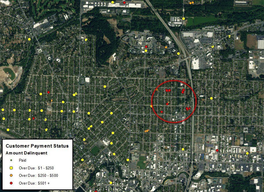
Cable and utility companies have credit and collection departments. The employees are dispatched into the field to collect overdue payments or turn off services due to non-payment.
Using an ERP/GIS system, planners could create routes to clusters of the highest-owing customers first.
Planners could also program the system to focus on dense populations like apartment complexes, where individual debts are small but collectively would represent a more cost-effective effort for the company.
The image above shows location and dollar range of delinquent customers. A collections group could use it to prioritize their work and maximize the return on their time and travel.
ERP/GIS FTW
The benefits of route optimization range from simple fuel cost savings to advanced geospatial routing parameters.
These results are only possible by using integrated ERP/GIS backend systems containing accurate data.
With that foundation in place, you can replace old-school address-based routing with highly accurate GIS-enabled routing.
And work smarter, not harder.
Chapters in this Series:
1 | 2 | 3 | 4 | 5 | 6 | 7 | 8 | 9 | 10